


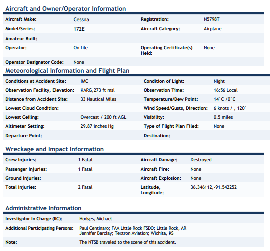
On December 26, 2021, about 1729 central standard time, a Cessna 172E airplane, N5798T,
was destroyed when it was involved in an accident near Hardy, Arkansas. The private pilot and
passenger sustained fatal injuries. The airplane was operated as a Title 14 Code of Federal
Regulations Part 91 personal flight.
A preliminary review of track data indicated that the airplane had already been airborne before
it was visible on radar. The airplane first appeared about 13 nm north of the Walnut Ridge
Regional Airport (ARG), Walnut Ridge, Arkansas, at 1627, at an altitude of about 2,500 ft. The
airplane flew generally south toward ARG until track data was lost at about 1643, 3.5 nm north
of ARG.
At 1653, about 3 nm north of ARG, the airplane reappeared in track data, climbing out of about
2,800 ft. The airplane flew left and right several times in a back and forth “s-type” movement
and then straightened out, flew west-north-west, and climbed to an altitude of about 4,500 ft,
then descended lower in the latter part of the flight.
At 1722, the airplane crossed over the Sharp County Regional Airport (CVK), Ash Flat,
Arkansas, from east to west at an altitude of about 4,000 ft. When the airplane was almost 2.5
nm west-north-west of CVK, the airplane turned right, descended slowly, and flew a track
consistent with an attempt to make an approach to CVK, then the airplane entered a tight left
turn and traveled to the north. During this time there were abrupt changes in ground speed,
altitude, and the direction of flight. The airplane executed at least one sharp counterclockwise
loop and flew generally north-north-east bound until track data was lost about 1728.
The Fulton County (Arkansas) Sheriff’s Office was provided copies of text messages the pilot
sent to a family member while in flight. One text message stated, “ran into weather can’t see
anything” and another text message later stated, “out of gas in air.”
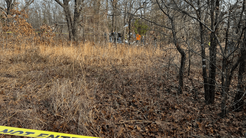
The wreckage, which was located on heavily wooded private property, was destroyed by the
impact sequence. The accident site is in the Ozark Mountains. The wreckage was recovered
from the accident site for a future examination.
Page 2 of 2 CEN22FA082
This is preliminary information, subject to change, and may contain errors. Any errors in this report will be corrected when
the final report has been completed.
A witness, who lives about 1 mile north of the accident site, reported that he observed “heavy
fog” in the area at the time and he estimated the visibility to be about 500 ft. Astronomical
conditions indicated the accident occurred right after the conclusion of civil twilight, which
occurred at 1726. Sunset occurred at 1657.
According to Federal Aviation Administration records, the pilot did not hold an instrument
rating.
For a Complete Look at All the Latest News Click Link Below